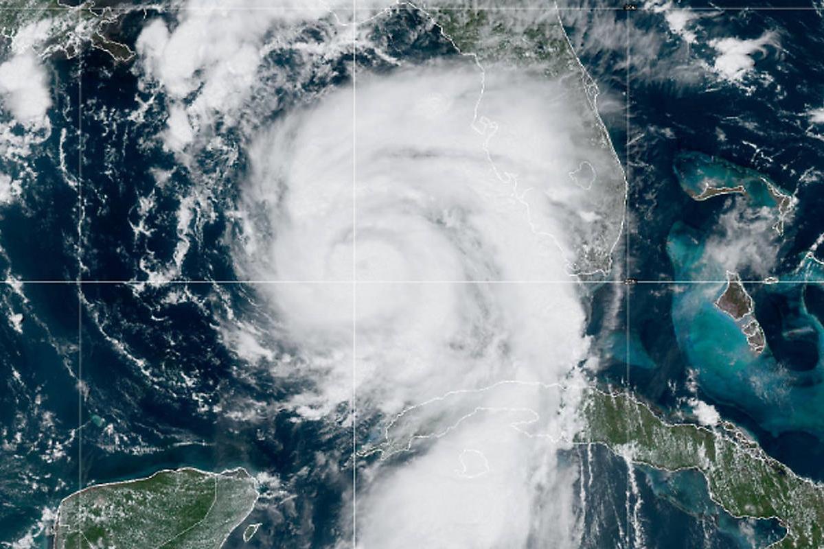
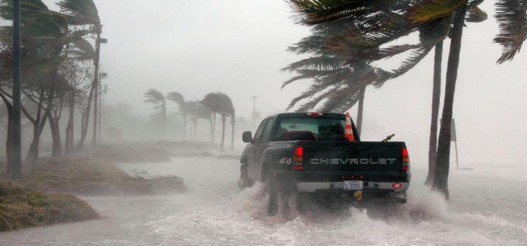
As Hurricane Idalia rapidly intensifies, Florida's Gulf coast residents are facing a race against time to evacuate ahead of the storm's destructive impact. With warnings of life-threatening storm surges and 125mph winds, more than a dozen counties have issued evacuation orders. As the first major hurricane to strike the US this year, Idalia's imminent landfall is predicted to occur early on Wednesday. The storm's journey from Cuba through the Gulf of Mexico has raised concerns of a Category 3 hurricane wreaking havoc upon its arrival.
As Hurricane Idalia advances towards Florida's Gulf coast, the storm's power is escalating. The storm evolved into a Category 1 hurricane overnight and was projected to further strengthen on Tuesday. The National Hurricane Centre (NHC) in Miami cautioned that Idalia's swift intensification was expected to continue.
"The stage is set for Idalia to rapidly intensify before landfall," warned specialist Eric Blake in a morning update. With the combination of warm and deep waters in the Gulf of Mexico, the hurricane was poised to become a dangerous major hurricane, raising concerns of its impact along Florida's west coast or Big Bend region.
While the storm's projected path shifted to the north, diverting it from the densely populated Tampa Bay area, residents were urged not to solely focus on the wind field. Authorities emphasised that the primary danger in such storms is water – storm surges and excessive rainfall leading to urban flash flooding. Deanne Criswell, administrator of the Federal Emergency Management Agency (FEMA), urged Floridians to listen to local officials and heed evacuation orders if issued.
Evacuation orders, both mandatory and voluntary, were issued in over 20 coastal Florida counties. Cedar Key's island city, for instance, was ordered to evacuate due to the potential impassability of bridges caused by storm surges. Florida's governor, Ron DeSantis, underscored the importance of prioritising safety, reminding residents that homes can be
Governor DeSantis took swift action by placing 46 of Florida's 67 counties under an emergency declaration. President Joe Biden's federal order unleashed resources, including FEMA search and rescue teams. The Florida National Guard was fully activated, with over 5,500 guardsmen and women prepared for action. Other state agencies and emergency response teams were also mobilised to aid recovery efforts and restore power.
Schools and colleges in the hurricane's path were shut down until at least Thursday, and aircraft and personnel at MacDill Air Force Base were evacuated. However, the state's major attractions like Disney World remained open, as they continued to prioritise guest safety.
Adding to the already dire situation, Hurricane Idalia's landfall coincides with a phenomenon known as "king tide." This term refers to unusually high ocean tides caused by the gravitational pull of the moon and sun. The projected landfall on August 30th, a full moon day, is expected to amplify tides along Florida's coast. These higher tides are likely to worsen flooding, especially when coupled with storm surge and excessive rainfall.
Florida categorises areas into evacuation zones, ranging from A (most vulnerable) to F (last to evacuate). Residents in evacuation zones, low-lying flood areas, or unsafe structures are urged to leave when evacuation orders are given. Essential items like phones, chargers, medications, identification, and cash should be packed in an emergency supply kit. Residents should also unplug appliances and turn off utilities before evacuating.
Evacuees must heed local authorities' instructions and choose safe routes, avoiding flooded roads. Pet owners should seek pet-friendly accommodations, and homeowners should secure their properties by boarding windows and clearing yards of debris.
As Hurricane Idalia threatens Florida's Gulf coast, a sense of urgency pervades the region. Evacuations are underway, and residents are preparing for the worst. The combination of a rapidly intensifying hurricane, life-threatening storm surges, and king tides creates a perfect storm of potential devastation. Amid the chaos, local authorities, state agencies, and federal resources are working together to safeguard lives and minimise the hurricane's impact on communities.
Share this story:
TweetBeyond the Headlines
Understanding Hurricanes: Nature's powerful and destructive phenomenon
A hurricane, known as a cyclone in some parts of the world, is a natural disaster that showcases the immense power of Earth's atmosphere. These swirling behemoths of wind and rain, often accompanied by towering waves, can wreak havoc on coastal regions and cause widespread devastation. Understanding the mechanics behind hurricanes and how they are categorised is essential for predicting and mitigating their impact on communities.
What is a Hurricane?
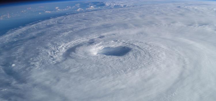
A hurricane is a large-scale tropical storm characterised by low atmospheric pressure, strong winds, and heavy rainfall. It forms over warm ocean waters in regions near the equator and gains energy from the latent heat released when water vapor condenses into liquid water. This process of heat exchange provides the necessary fuel for the storm's intensification. Hurricanes typically have a well-defined center, called the eye, which is an area of relatively calm weather surrounded by the eyewall - a ring of intense thunderstorms.
Formation and Development
Hurricanes are born over warm ocean waters with sea surface temperatures of at least 26.5 degrees Celsius (79.7 degrees Fahrenheit). Warm, moist air at the surface rises and begins to cool as it ascends. This cooling causes the water vapor to condense into clouds, releasing latent heat into the atmosphere. This heat release warms the surrounding air, causing it to rise as well. As more warm, moist air rushes in to replace the rising air, a cycle of convective activity is established.
If the atmospheric conditions are conducive and there is a sufficient distance from the equator to allow the Coriolis effect to kick in, a developing storm can start to spin due to the Earth's rotation. This rotation, caused by the Coriolis effect, imparts the storm its characteristic cyclonic structure. As the storm continues to gather energy from the warm ocean waters, it intensifies and can develop into a hurricane.
What is the Coriolis effect?
The Coriolis effect is a phenomenon that results from the rotation of the Earth. As the Earth rotates on its axis, objects on its surface are subject to an apparent deflection in their paths due to the Earth's rotation. This effect causes moving air, water, and other fluids to curve as they travel across the Earth's surface.
Categorising Hurricanes: The Saffir-Simpson Scale
To quantify the intensity of hurricanes and provide a standardised way to communicate their potential impact, meteorologists use the Saffir-Simpson Hurricane Wind Scale. This scale categorises hurricanes based on their sustained wind speeds and potential damage.
The Saffir-Simpson scale consists of five categories:
Category 1 (74-95 mph / 119-153 km/h):
Hurricanes in this category are considered to cause minimal damage. They produce mild storm surges and damage to unanchored mobile homes, trees, and power lines.
Category 2 (96-110 mph / 154-177 km/h):
Hurricanes in this category cause moderate damage. They can result in extensive power outages, uprooted trees, and structural damage to poorly constructed buildings.
Category 3 (111-129 mph / 178-208 km/h):
These hurricanes are considered major storms. They can cause devastating damage, including extensive tree loss, power outages lasting weeks, and well-built framed homes being severely damaged.
Category 4 (130-156 mph /r 209-251 km/h):
These hurricanes cause catastrophic damage. They can lead to power outages lasting months and result in residential areas being isolated due to fallen trees and power poles.
Category 5 (157 mph / 252 km/h or higher):
The most severe hurricanes fall into this category. They cause catastrophic damage, with most trees snapped or uprooted and power poles knocked down. Residential areas can be isolated for weeks or months due to the extent of destruction.
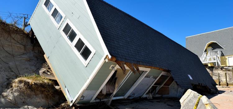
The Role of Storm Surge
In addition to wind speeds, storm surge is a critical factor in the destructive potential of hurricanes, particularly for coastal areas. Storm surge is the abnormal rise in sea level generated by a hurricane's winds. As a hurricane approaches the coast, its powerful winds push water toward the shore, causing the sea level to rise significantly. This surge of water can inundate coastal areas, causing extensive flooding and erosion. The combination of high winds, heavy rainfall, and storm surge can lead to a disastrous scenario for communities in the storm's path.
Predicting and Mitigating Impact
Advanced meteorological technology and computer models have significantly improved the ability to predict the paths and intensities of hurricanes. This forecasting allows authorities to issue timely warnings, giving residents in vulnerable areas time to evacuate and prepare.
Mitigating the impact of hurricanes involves a combination of preparedness, engineering, and infrastructure planning. Coastal communities often have building codes designed to withstand certain wind speeds, and storm-resistant infrastructure can be put in place to protect against storm surges. Early warning systems, emergency response plans, and evacuation routes are crucial for minimising casualties.
In recent years, researchers have also been studying ways to weaken hurricanes before they make landfall. Some proposed methods include cooling the ocean surface to deprive the storm of its heat source or using wind turbines to disrupt the storm's circulation. However, these approaches are still in their experimental stages and raise ethical and environmental concerns.
There are several reputable organisations and sources where you can find more information about hurricanes:
National Hurricane Centre (NHC):
The NHC, part of the National Oceanic and Atmospheric Administration (NOAA) in the United States, is one of the primary sources of information on hurricanes. They provide forecasts, tracking, and updates on current and potential hurricanes.
World Meteorological Organisation (WMO):
The WMO is a specialised agency of the United Nations responsible for promoting international cooperation in meteorology, climatology, hydrology, and related fields. They provide global perspectives on hurricanes and other weather-related events.
Hurricane Research Division (HRD):
Also part of NOAA, the HRD focuses on hurricane research, including the study of hurricane intensity and structure. They provide valuable insights into the science behind hurricanes.
European Centre for Medium-Range Weather Forecasts (ECMWF):
This organisation provides medium-range and long-range weather forecasts and climate services. They offer information about hurricanes and other weather-related phenomena from a European perspective.
Joint Typhoon Warning Centre (JTWC):
Operated by the United States Navy and Air Force, the JTWC provides typhoon and tropical cyclone forecasts for the Pacific and Indian Oceans. While it's more focused on typhoons, the information is relevant to hurricanes as well.
National Aeronautics and Space Administration (NASA):
NASA conducts satellite observations and research related to hurricanes, providing valuable visualisations, data, and insights about these storms from space.
Federal Emergency Management Agency (FEMA): FEMA provides resources and information related to disaster preparedness and response, including hurricanes. They offer guidance on how to prepare for and stay safe during hurricanes.
American Red Cross:
The American Red Cross offers information and resources for hurricane preparedness, response, and recovery. Their guidance includes safety tips, emergency kits, and evacuation plans.
Weather Outlets:
Outlets that provide in-depth weather information, such as The Weather Channel, AccuWeather, and Weather.com, provide comprehensive coverage of hurricanes, including forecasts, tracking, and safety information.
Educational Institutions:
Many universities and research institutions conduct studies on hurricanes and their impacts. Their websites and research papers can provide in-depth scientific knowledge about these storms.
Search
Keywords
More Stories
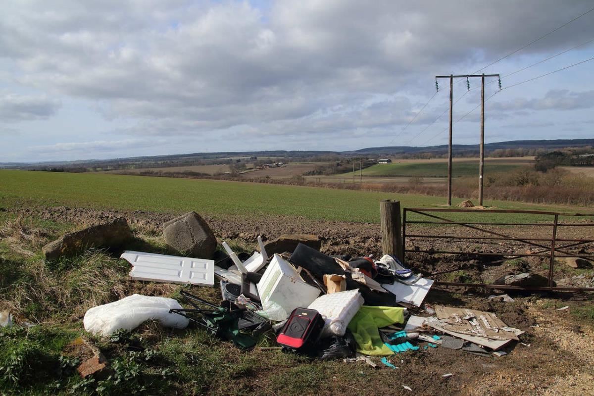
Multi-agency operation strikes in Chichester against fly-tipping menace
Chichester District Council joins forces with Sussex Police, the DVSA, and the Environment Agency to end illegal waste disposal.
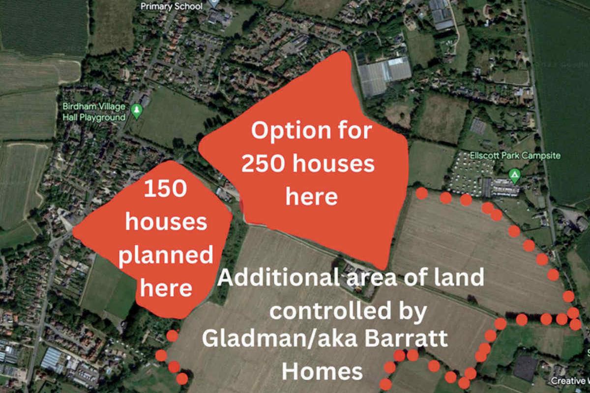
Controversial house development plans emerge on the Manhood Peninsula in Birdham
Controversial housing plans in Birdham, West Sussex, spark debates on development's impact. Appeals to decide fate.

Prince William surprises with environmentally friendly burgers in South London
In a delightful surprise, Prince William personally served environmentally friendly burgers from a food truck in South London.
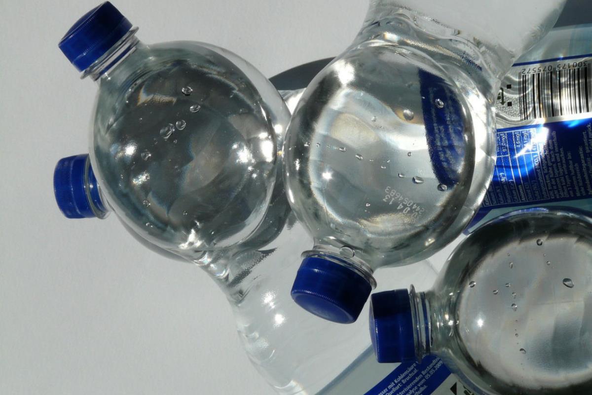
Converting polyethylene into detergent: A breakthrough in plastic upcycling
From polyethylene to detergent: VA Tech breakthrough converts plastic waste into valuable soap, reshaping recycling.
News Categories
Picks

Effortless Cleaning: A captivating adventure with the Gtech AirRAM cordless vacuum
Buckle up as I put the Gtech AirRAM MK2 cordless vacuum cleaner through its paces.

Live Your Good Life with Good Life Plus: A Fun-Filled Adventure Awaits
Daily prize draws, incredible discounts, and unforgettable experiences await. Sign up today and start living your best life!

Amazon Prime Try Before You Buy: A game-changer for fashion enthusiasts
Amazon's Prime Try Before You Buy service takes this concept to the next level, making it an absolute must for any fashion-forward individual.

Unleash your inner beard aficionado: Mo Bro's XL Beard Maintenance Grooming Kit
A revitalising grooming journey with the Mo Bro's XL Beard Kit. Elevate your beard game with precision care.
Picks Categories
Find picks by category: